River Alert -Willamette River Shoals Surprise Boaters (Photo) - 07/01/20
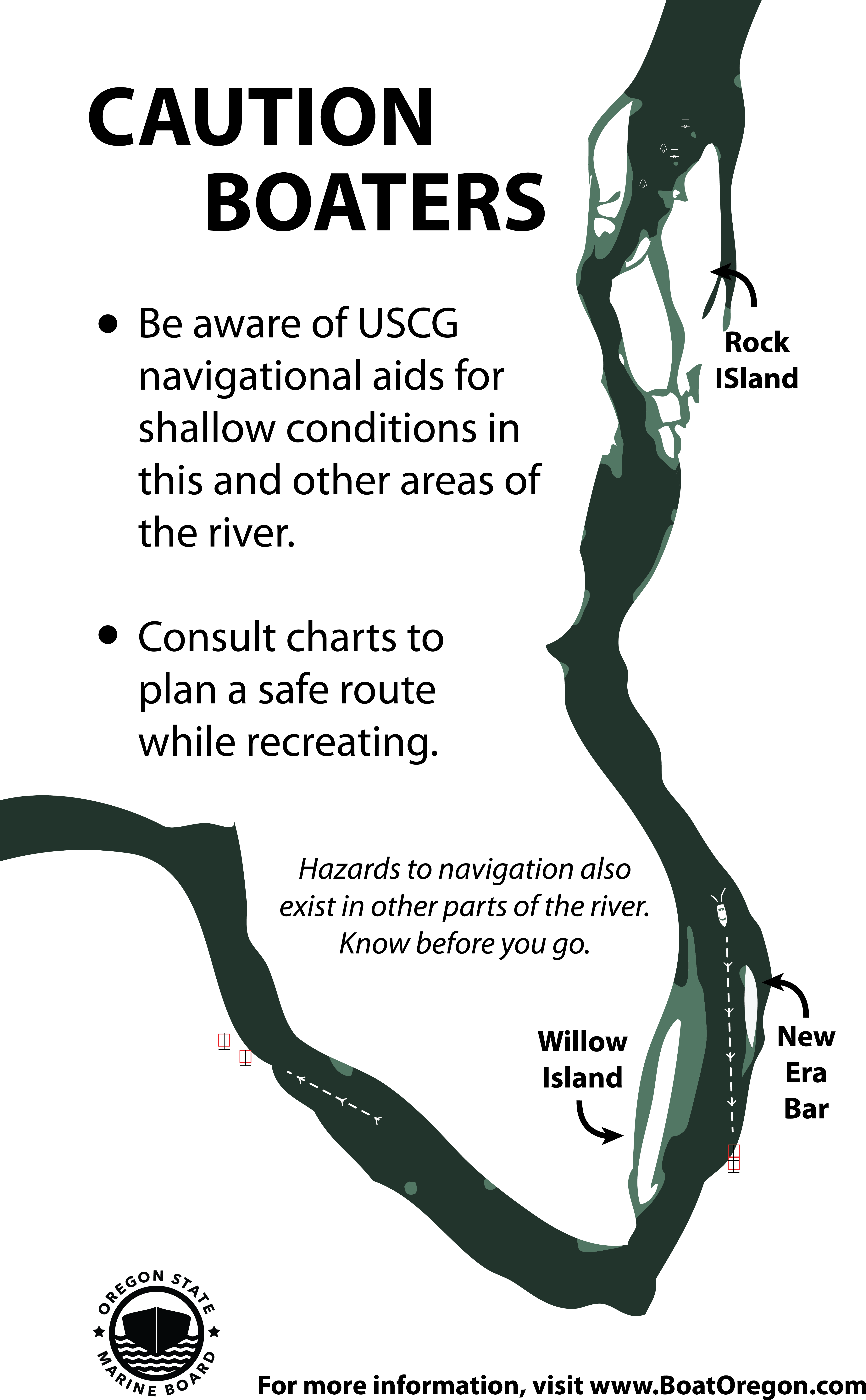
The Oregon State Marine Board annually receives complaints from boaters grounding on shoals and sandbars on the Willamette River, especially near Willow Island and New Era Bar, located at RM 32 near Canby. From the surface, the river can be deceiving. The channel is narrow and takes an intentional effort to learn how to navigate. Here are some pointers on finding the channel in this stretch of the river for motorboats:
- Line up the range markers on the banks of the river (to the north and south) to identify the channel.
- Seasonal red and green buoys are maintained by the US Coast Guard and mark the channel at its narrowest point.
- Depth finders and chart plotters are a valuable aid in determining underwater obstructions, hazards and shoals that exist in many areas of the river.
- Digital charts are available from NOAA for the Willamette River. Paper charts are also available at nautical supply stores, many fishing tackle shops, and will show historically shallow areas. Local boating retailers are an excellent source of information as well.
- Note that all charts and all other references can become out-of-date quickly depending on winter flows and moving sands and debris.
Large trees with root balls and shifting sand bars can become obstructions upon which an operator can ground a boat, damage a propeller or break an outdrive unit at any time, at any location, on any Oregon River. It is incumbent on the boat operator to start slow to observe the conditions, survey the area, and use these tried-and-true tools.
A question agency staff are routinely asked is, “Why doesn’t the Marine Board better mark these areas with buoys?” The decision to place a waterway marker is based, in part, on the geography of the area and existing navigation markers. This shallow area at river mile 32 on the Willamette River is already marked with range markers, US Coast Guard buoys, and is well-described on nautical charts. Plus, it changes little from year to year. In addition, the shallow areas are primarily bedrock and river currents make it very difficult to permanently affix buoys, even with heavy anchors.
Oregon’s rivers are dynamic and ever-changing. Boaters assume the obligation to know the waterway and operate responsibly. Operators should understand that an area has hidden obstructions until they have surveyed it, especially in tidally influenced areas and rivers or areas with stronger currents.
A good primer and tutorial on navigation aids can be found at https://www.uscgboating.org/images/486.PDF.
###