The Board of County Commissioners selected “Map J” – one of three options presented by the County’s Independent Redistricting Committee (IRC) – to serve as the updated boundaries for the five county commissioner districts. The vote was 3-2.
The selected map can be viewed at https://bit.ly/LaneMapJ.
The Board held virtual public hearing sessions on November 30 and December 1, as well as accepted written testimony over a period of several weeks, before voting on the evening of December 1.
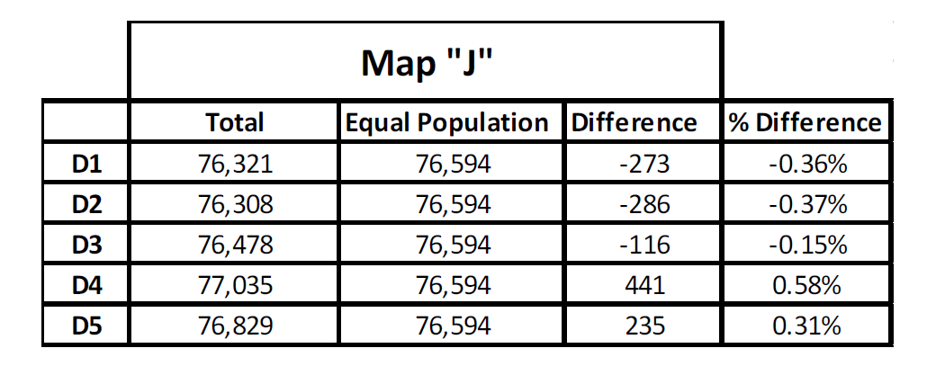
A primary objective for the IRC’s work was creating districts with populations as equal as practicable. Evenly dividing the county population among five districts would result in districts of 76,594 residents. The IRC decided that a 1 percent variance was acceptable. See the attached population table for details.
Further, the Lane County Charter describes commissioner districts that are “generally comprised” of Lane County within and outside of the metropolitan areas of Eugene and Springfield. As the population growth in our county is concentrated within the Urban Growth Boundary, the IRC also had to work to present options that met – as closely as possible – the Charter description.
As outlined in a summary by the IRC, the selected map strives to unify the River Road/Santa Clara neighborhoods. It places unincorporated portions of the River Road/Santa Clara neighborhoods in a commissioner district that represents other unincorporated areas. It also utilizes the natural geographic boundary of the Willamette River to the East of the River Road/Santa Clara area and the railroad tracks to the west that cut off transportation links from the River Road/Santa Clara area to the Coburg Road and Bethel areas. The selected map strives to unify the Bethel School District within one commissioner district and to maintain Districts 1 and 5 as primarily outside of Eugene and Springfield city limits; excepting the River Road/Santa Clara neighborhoods which are placed in District 1 and the Churchill region which was placed in District 5 in the 2011 maps and remains in District 5 in this map.
The new district boundaries – along with any other political boundary changes from governments – will be provided to the Lane County Elections Office so that ballot information can be updated by the January 31, 2022 deadline.
About the Independent Redistricting Committee
Lane County’s Home Rule Charter requires that boundaries for Lane County commissioner districts be evaluated and updated at least once every ten years. The previous redistricting effort was completed in 2011.
The Independent Redistricting Committee (IRC) was composed of fifteen (15) members. The IRC met several times this fall to create 19 different district maps that were refined through committee discussion and public feedback. Ultimately provided three redistricting options to the Board of County Commissioners in November.
In addition to the later public hearings held by the Board of County Commissioners, the IRC provided opportunities for public comment at each of its meetings.
The IRC was only responsible for redistricting the five county commissioner districts. The Sheriff, District Attorney and Tax Assessor are elected by all Lane County voters and do not have sub-districts.
Information about the IRC can be found at www.LaneCountyOR.gov/IRC.
###